|
travel@pangolin.liNamibia 2003
|
 |
 |
www.pangolin.li
home Travel
directory Travel
directory Namibia 2003
Main
Part 1 Etosha
Part 1a
Animals Part 2
Otjitotongwe Part 3 Highlands Part 4 Van Zyl's
P. Part 5 Marienfluss Part 6 Kaokoveld
Part 7 Damaraland Part 8 Twyfelfontein Part 9 Namib Part 10 Wolwedans Part 11 Gamsberg Panorama pics Namibia '03 Gallery
Namibia 2003
Main
Part 1 Etosha
Part 1a
Animals Part 2
Otjitotongwe Part 3 Highlands Part 4 Van Zyl's
P. Part 5 Marienfluss Part 6 Kaokoveld
Part 7 Damaraland Part 8 Twyfelfontein Part 9 Namib Part 10 Wolwedans Part 11 Gamsberg Panorama pics Namibia '03 Gallery |
|
contact last updated: 2-Aug-2005 Text/pictures subject to copyright by pangolin.li |
 |

 |
||||||||||||||||||||
Part 8 - Damaraland tourist attractions:Twyfelfontein Rock Art, Burnt Mountain, Organ Pipes, Petrified Forest, Welwitscha, Doros Crater and BrandbergPlease check out this link to our Namibia '05 trip in the same region. Go directly to: Twyfelfontein, Petrified Forest/Organ Pipes, Burnt Mountain/Doros Crater/Brandberg, Doros-Swakopmund.
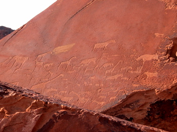
Contact me if you'd like to get our GPS data of this trip. And do check out our Namibia '03 photo Gallery. TwyfelfonteinDamaraCamp was close to civilisation, as we had seen several lights at night. So after breaking camp we passed the Twyfelfontein Lodge Airstrip (S20 32 40.2 E14 21 03.8) after 12 km, and proceeded to Twyfelfontein. Nature formed an enormous arena made of rock, which San artists used for their paintings and engravings.At the house down in the "arena" is the reception with some info panels and a curio shop. You have to hire a guide for the walk to the rock art - all of them young locals with good knowledge of the site. The tour of the rock paintings starts with a walk uphill - luckily it was still cool, early in the morning. Our guide showed us several engravings of animals: notably a panel with an overview of many animals known to prehistoric San, including seals which can only be found 150 km away at Skeleton Coast, or hippos which are better known from Okavango). Obviously San travelled far... Then we also saw rock paintings in a cave - please see the panorama page. In total we've seen ca. 15 rock art sites on the 1 hr walk, but there were many more. Check out these tourist or scientific links for more info on Twyfelfontein rock art. Note that the Twyfelfontein Lodge close by has a fuel station, but it is not always operational.
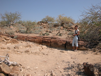
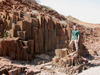
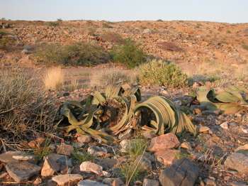
Petrified Forest and Organ PipesNext on our list was the Petrified Forest on the Bergsig-Khorixas road (S20 26 22.2 E14 36 23.0) - a detour of more than 100 km, but I really wanted to see it (if I had known that we would pass it again next day...). It was interesting, but not worth the detour - I'm a biologist, not a geologist. The site offers a guided tour of several of the ca. 50 trees. They are more than 250 million years old, and were petrified probably after a flood had buried them under silica-rich mud. Some of the trees look really like living trees, with bark and year rings. Also interesting for me was my first Welwitschia mirabilis. There is a small bar offering cool soft drinks, and many curio and stone shops. I bought several things there, because they looked handmade and local, not like in more touristy areas where you see the same curios "made in Kenya" everywhere.After this, we drove back to see the Organ Pipes (S20 36 46.7 E14 24 56.8) and Burnt Mountain, which is just around the corner to Twyfelfontein. The Organ Pipes are of volcanic origin; the dolerite stone cooled too quickly, so it broke into octagonal columns like organ pipes. Again an interesting geological thing, but I wouldn't travel long to see it. Special here are some of the smaller pebbles lying around in the upper part: they are the material which the Himba women grind to apply to their skin - and you can use them to draw.
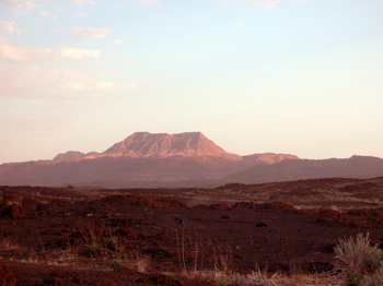
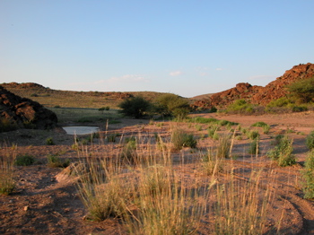
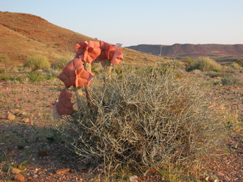
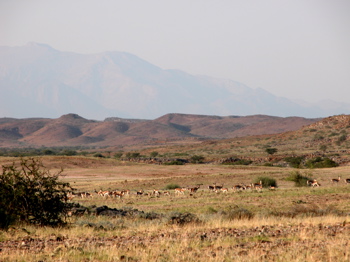
Burnt Mountain, Doros Crater and BrandbergThe road leading to the Organ Pipes goes on and passes East of Burnt Mountain. Gerry had told us that there is a track leading from there to Brandberg and another to Ugab Base Camp, the latter leading around Doros Crater.We intended to take the route to Ugab Base Camp; however, we didn't have a detailed map or GPS coordinates at that time. In essence: we didn't get to Ugab Base Camp. We turned too early - not just because we had a flat tire... But the drive was enormously beautiful. So if you plan to go there, use a very detailled map (the Henties Bay Tourist Office sells route descriptions; you can get them there or in the garage/gas station at the Northern end of Henties Bay; or else email me for the GPS coordinates of our 2005 trip). This is really a 4WD route, so take care to drive slowly and don't leave the tracks (some parts of the roads are not very good, and tracks off the path probably remain for very long); it is a lonely region, so take the necessary precautions. The rewards were manyfold: beautiful landscape with views to the Burnt Mountain to one side and Brandberg in the mist to the other. Endless rolling hills. Big herds of springbok and zebra. A small gorge, where we saw a Hoodia, a strange kind of plant (see photo) whose enormous flowers, at first sight, looked like a plastic bag to me. We turned back in the afternoon and decided not to go back to Twyfelfontein, but to build camp somewhere in the Doros region. After passing an old rusty car, we set up camp near a solid stone house (S20 44 55.7 E14 22 52.0) - Pathfinder Camp.
From Doros to SwakopmundThe next day, we tracked back to Burnt Mountain and drove on via Khorixas, Uis, Hentiesbaai to Swakopmund. Near Abu Huab Lodge we took a guy hiking a ride with us, who wanted to get to Khorixas to meet his family. He was working in a new lodge near Twyfelfontein; it was very interesting to chat with him about his job there, the tourists, and his family in Khorixas.The landscape turned very nice soon after Petrified Forest, with many round hills sitting in the meadows like mushrooms. Soon after, traffic got more intense around Khorixas and Uis. We then took the long and straight road towards the coast, with the surroundings getting barren - until the coastal fog appears like a wall towards which you drive. We didn't see sunlight again until next morning, when leaving Swakopmund. In Henties Bay we had our flat tire mended, and then drove on to Swakopmund. Top of page Go to:
|
||||||||||||||||||||
 |