|
travel@pangolin.liNamibia 2003
|
 |
 |
www.pangolin.li
home Travel
directory Travel
directory Namibia 2003
Main
Part 1 Etosha
Part 1a
Animals Part 2
Otjitotongwe Part 3 Highlands Part 4 Van Zyl's
P. Part 5 Marienfluss Part 6 Kaokoveld
Part 7 Damaraland Part 8
Twyfelfontein Part 9 Namib Part 10 Wolwedans Part 11 Gamsberg Panorama pics Namibia '03 Gallery
Namibia 2003
Main
Part 1 Etosha
Part 1a
Animals Part 2
Otjitotongwe Part 3 Highlands Part 4 Van Zyl's
P. Part 5 Marienfluss Part 6 Kaokoveld
Part 7 Damaraland Part 8
Twyfelfontein Part 9 Namib Part 10 Wolwedans Part 11 Gamsberg Panorama pics Namibia '03 Gallery |
|
contact last updated: 30-Jul-2005 Text/pictures subject to copyright by pangolin.li |
 |

 |
||||||||||||||||
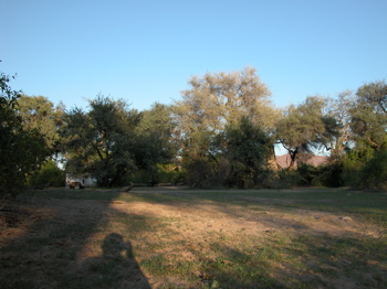
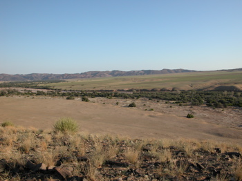
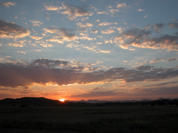
Part 7 - Purros, Sesfontein, Huab and DamaralandPlease check out this link to our Namibia '05 trip in the same region.Go directly to Purros, Purros to Sesfontein, Sesfontein to Palmwag or From Palmwag to Huab and DamarCamp. Travel DetailsPurros (km 585) is the first settlement after 100s of kilometres. We stayed at the Purros Community Campsite, where we also made a guided afternoon excursion up Hoarusib river (41 km). The next day we followed the Gomadommi river to Tomakas (km 668), then over the Giribes plain and Ganumub (km 703) to Sesfontein (km 740). Sesfontein is the first point after Opuwo with fuel, tube repair stall, a basic shop (staples, water and frozen meat) and a bottle store.For the alternative route to Sesfontein via Amspoort and the Hoanib riverbed, check out my diary of our 2005 trip here. From Sesfontein we drove via Khowarib (km 773) on to Palmwag (km 849, also with gas station) where we stayed for the night. The next day, we made first a guided excursion into "Rhino Valley" starting 9 km south of Palmwag, and afterwards (km 905) drove on via Bergsig (km 942), 7 Myl Pass (km 956) to the place where the road meets Huab river (which would be at km 968, but we missed it and turned at the junction of C39 and D2612, so coming back to Huab we were at km 1006). We now cut into the dry Huab river bed and followed it until km 1037, where we turned because of an upcoming sandstorm. Driving back, we exited Huab in De Riet (km 1057). We went over a moon landscape pass (km 1063) and camped in the plains ca. 12 km from the Twyfelfontein airstrip - "Damara Camp" (km 1066). Contact me if you'd like to get our GPS data of this trip. And do check out our Namibia '03 photo Gallery. 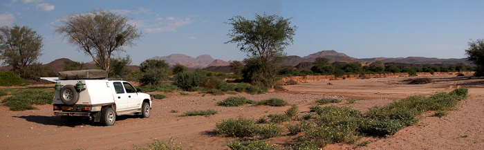 In the Huab riverbed Top of page PurrosPurros' appearance is stunning. Coming from the endless gold-grey plains of the North, drive over a small koppie and the view opens over a huge green slope with a river and a village at the bottom. I got out to take pictures - and almost stumbled over two gemsboks who enjoyed the same view (or some good grass).The Purros Community Campsite - or formally: Ngatutunge Pamwe Campsite - is located outside of the village on the other side of Hoarusib river. The river flows most of the year (it's the same we had crossed six days earlier). The campsite is really at the river or its sidearms; it has a central reception building which also sells cool drinks and firewood, and four very secluded campsites - you don't see the other campers, really. Arriving early, we could choose our campsite. It was close to the river, shaded by big trees and inhabited by a squirrel and two excited francolins. It offered a braai area, and a flush toilet and a warm shower in an open-air "room" made of reed. Very romantic.
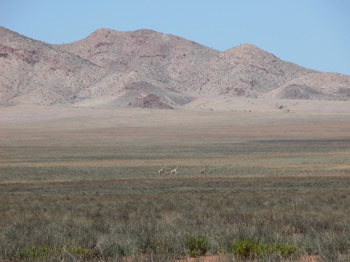
Two nights ago, elephants had wandered through the camp. So we set out in an (unsuccessful) quest to search for them, up the river. A local guide led us to many beautiful spots, including a hill overlooking the whole valley, but he got very desperate when he couldn't locate an elephant... no problem at all, now we've got another reason to come back to Purros. The sunset drive was special, nevertheless. Top of page Purros to SesfonteinThe next morning (starting at km 626, after the Hoarusib excursion), we set out very soon, crossed the river, and turned into Gomadommi valley soon after Purros. We decided not to take the path to Amspoort (turn-off at km 636), but to follow the better road to Tomakas, Giribes plain and Sesfontein. In Tomakas, we stopped for a chat with locals - they seemed to be used to tourists leaving medicines, so they asked again for eyedrops. One of the kids had his eyes almost closed by encrustations, so I washed it with clean water - but no eyedrops, sorry. They told us that a mobile doctor comes to see them regularly.The narrow Gomadommi valley opened up into Giribes plain, where we suddenly noticed three desert giraffes galloping towards us! We've seen neither man nor animal chasing them, so no idea why the fled towards us. They kept safe distance and later wandered away.
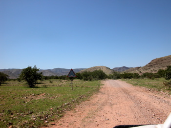
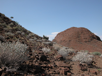
The route to Sesfontein was eventless except for a nice little pass and a road sign - the first since 700 km! Sesfontein is an old German fort, and has a fuel station and a restaurant. While fueling I noticed an elephant/giraffe sign on the car beside us, and started a chat with the driver. His name is Keith, and he leads the research project for desert-dwelling elephants and giraffes, based in Outjo. We joined him for a cool rock shandy, and learnt much about the elephants we hadn't seen. He told us to come back in September (this is what we did in 2005, check out this link here)... Top of page Sesfontein to PalmwagAfter the break in Sesfontein, we moved on to Palmwag (km 849), without further stop. Palmwag Lodge is quite a change after Kaokoveld: It has a gas station, a pool surrounded by palm trees, a restaurant with à la carte menu, a pool bar and a resident house cat. In order to not suffer from culture shock, we decided to stay in our roof tent in the Palmwag camp site. The site is not big, but offers clean facilities. We spent the afternoon at the pool, then had a braai with the South Africans we had met twice before at the Cunene rapids and Rooidrum, and then went to the bar for a drink. There we met Gerry Maritz - not the actor, but a tour guide from Swakopmund who spent a free day here. He really knew his way around here, and gave us several tips of nice lonely sites to visit by 4x4 - we attempted several of them during the coming days! So if you plan to hire a tour guide for an exclusive 4x4 trip in Namibia, let me give you Gerry's contact details!Gerry also introduced us to John, who would act as our guide in an excursion into Rhino Valley south of Palmwag. John started a public campsite (S19 55 35.1 E13 58 47.8), which was being upgraded at that time - so we'll check it out next time. The excursion didn't lead us to rhinos, but we saw kudu, zebras - and huge euphorbias! From Palmwag to Huab and Damara CampAfter the excursion, we took John to Bergsig, the next settlement, and drove on via the steep 7 Myl Pass, with scenic view over the Damaraland mountains. According to a tip from Gerry, we entered the Huab riverbed (S20 21 11.9 E14 11 40.2; km 1006, after wrong navigation, see travel details) for some more off-road adventure. It was hot, but very idyllic. There was a basalt hill (S20 30 43.6 E14 05 44.2) looking similar to the Organ Pipes we would see the next day. Our path meandered on - until the air became stiffling hot, and a sand storm arose. We were afraid that the sand would stop us here, so we turned (S20 31 41.0 E14 03 03.6).We drove back and left the sandy riverbed at De Riet (S20 28 04.5 E14 11 17.5), a small village at the confluence of Huab and Aba Huab, consisting of only a few houses and a "Drankwinkel". We didn't stop (what a pity, I should have liked to chat with the old man sitting in front of the drankwinkel), but drove on, up a little pass. The landscape changed to black rocks, somehow lunar. And the view from top to Burnt Mountain was gorgeous! However, it was too windswept and seemed somehow like a military site, so we drove down to the plane where we set up camp for the night - "Damara Camp" (S20 28 22.9 E14 15 37.3). Instead of a braai, JJ prepared his all-time favourite, spaghetti with tomato sauce. Excellent!
Top of page Go to:
|
||||||||||||||||
 |